The Mariana Trench or Marianas Trench is the deepest part of the world's oceans. It is located in the western Pacific Ocean, to the east of the Mariana Islands. The trench is about 2,550 kilometres (1,580 mi) long but has a mean width of only 69 kilometres (43 mi). It reaches a maximum-known depth of ab
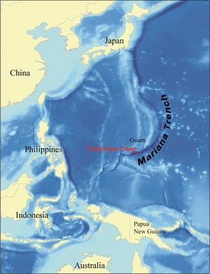
A map of the Mariana Trench.
out 10.91 kilometres (6.78 mi) (35,800 ft) at the Challenger Deep, a small slot-shaped valley in its floor, at its southern end, although some unrepeated measurements place the deepest portion at 11.03 kilometres (6.85 mi).
At the bottom of the trench, where the plates meet, the water column above exerts a pressure of 1,086 bars (15,750 psi), over one thousand times the standard atmospheric pressure at sea level. At this pressure the density of water is increased by 4.96%, making ninety five litres of water under the pressure of the Challenger Deep contain the same mass as a hundred litres at the surface. The temperature at the bottom is 1 to 4 ⁰C.
The trench is not the part of the seafloor closest to the center of the Earth. This is because the Earth is not a perfect sphere: its radius is about 25 kilometres (16 mi) less at the poles than at the equator. As a result, parts of the Arctic Ocean seabed are at least 13 kilometres (8.1 mi) closer to the Earth's center than the Challenger Deep seafloor.
Xenophyophores have been found in the trench at a record depth of 10.6 km (6.6 mi) below the sea surface.
Name
The Mariana Islands were claimed by Spain in 1668. Spain established a colony there, and gave the islands the official title of Las Marianas in honor of Spanish Queen Mariana of Austria, widow of Philip IV of Spain. The islands are part of the island arc that is formed on the over-riding plate, the Mariana Plate, on the western side of the trench. The Pacific plate is being subducted under the islands, forming the trench.
Geology
The Mariana Trench is part of the Izu-Bonin-Mariana Arc geological boundary system that forms the boundary between two tectonic plates. In this system, the western edge of one plate, the Pacific Plate, is subducted beneath the smaller Mariana Plate that lies to the west. Because the Pacific plate is the largest of all the tectonic plates on Earth, crustal material at its western edge has had a long time since formation (up to 170 million years) to compact and become very dense; hence its great height-difference relative to the higher-riding Mariana Plate, at the point where the Pacific Plate crust is subducted. This deep area is the Mariana Trench proper. The movement of these plates is also indirectly responsible for the formation of the Mariana Islands (which are caused by volcanism as a result of subduction of water trapped in minerals).
Measurements
The trench was first sounded during the Challenger expedition (December 1872 – May 1876), which recorded a depth of 4,475 fathoms, 8,184 m (26,850 feet). In 1877 a map was published calledTiefenkarte des Grossen Oceans by Petermann, which showed a Challenger Tief at the location of that sounding. In 1899 USS Nero, a converted collier, recorded a depth of 5269 fathoms (9,636 m, 31,614 ft). Challenger II surveyed the trench using echo sounding, a much more precise and vastly easier way to measure depth than the sounding equipment and drag lines used in the original expedition. During this survey, the deepest part of the trench was recorded when the Challenger II measured a depth of 5,960 fathoms (10,900 m, 35,760 ft) at 1°19'N 142°15'E, known as the Challenger Deep.
In 1957, the Soviet vessel Vityaz reported a depth of 11,034 m (36,201 ft), dubbed the Mariana Hollow.
In 1962, the surface ship M.V. Spencer F. Baird recorded a maximum depth of 10,915 m (35,840 ft), using precision depth gauges.
In 1984, the Japanese survey vessel Takuyō (拓洋), collected data from the Mariana Trench using a narrow, multi-beam echo sounder; it reported a maximum depth of 10,924 m, also reported as 10,920 metres ± 10 metres.
During surveys carried out between 1997 and 2001, a spot was found along the Mariana Trench that had depth similar to that of the Challenger Deep, possibly even deeper. It was discovered while scientists from the Hawaii Institute of Geophysics and Planetology were completing a survey around Guam; they used a sonar mapping system towed behind the research ship to conduct the survey. This new spot was named the HMRG (Hawaii Mapping Research Group) Deep, after the group of scientists who discovered it.
On 1 June 2009 sonar mapping of the Challenger Deep by the Simrad EM120 sonar multibeam bathymetry system for deep water (300 – 11,000 m) mapping aboard the RV Kilo Moana (mothership of the Nereus vehicle), has indicated a spot with a depth of 10,971 m (35,994 ft). The sonar system uses phase and amplitude bottom detection, with an accuracy of better than 0.2% of water depth across the entire swath (implying the depth figure is accurate to less than ± 22 metres).
In 2011, it was announced at the American Geophysical Union Fall Meeting that a US Navy hydrographic ship equipped with a multibeam echosounder conducted a survey which mapped the entire trench to 100 m resolution. The mapping revealed the existence of four rocky outcrops thought to be former seamounts.
The Mariana Trench is a site chosen by researchers at Washington University and the Woods Hole Oceanographic Institution in 2012 for a seismic survey to investigate the subsurface water cycle. Using seismometers and hydrophones the scientists are able to map structures as deep as 60 mi (97 km) beneath the surface.
Descents
This was followed by the unmanned ROVs Kaikō in 1996 and Nereus in 2009. The first three expeditions directly measured very similar depths of 10,902 to 10,916 m.Four descents have been achieved. The first was the manned descent by Swiss-designed, Italian-built, United States Navy-owned bathyscaphe Trieste which reached the bottom at 1:06 pm on 23 January 1960, with U.S. Navy Lieutenant Don Walsh and Jacques Piccard on board. Iron shot was used for ballast, with gasoline for buoyancy. The onboard systems indicated a depth of 11,521 m (37,799 ft) but this was later revised to 10,916 m (35,814 ft) the depth was estimated from a conversion of pressure measured and calculations based on the water density from sea surface to seabed.
The fourth was made by Canadian film director James Cameron in 2012. On 26 March, he reached the bottom of the Mariana Trench in the submersible vessel, the Deepsea Challenger. The exploration was co-sponsored by The National Geographic Foundation and Rolex.
Planned descents
As of February 2012, at least three other teams are planning piloted submarines to reach the bottom of the Mariana Trench. These include: Triton Submarines, a Florida based company that designs and manufactures private submarines, for which a crew of three will take 120 minutes to reach the seabed; Virgin Oceanic, sponsored by Richard Branson's Virgin Group, designed by Graham Hawkes, and piloted by Chris Welsh, for which the solo pilot will take 140 minutes to reach the seabed; and DOER Marine, a marine technology company, based in San Francisco and set up in 1992, for which a crew of two or three will take 90 minutes to reach the seabed.
Life
The expedition conducted in 1960 observed (with great surprise because of the high pressure) at the bottom large living creatures such as a sole or flounder about 30 cm (1 ft) long, and a shrimp. According to Piccard, "The bottom appeared light and clear, a waste of firm diatomaceous ooze".
During the second expedition, the unmanned vehicle Kaikō collected mud samples from the seabed. Tiny organisms were found to be living in those samples.
On July 2011 a research expedition deployed untethered landers, called dropcams, equipped with digital video and lights to explore this region of the deep sea. Amongst many other living organisms, some gigantic single-celled amoebas with a size of more than 4 inches (10 centimeters), belonging to the class of xenophyophores. Xenophyophores are noteworthy for their size, their extreme abundance on the seafloor and their role as hosts for a variety of organisms.
Possible nuclear waste disposal site
Like other oceanic trenches, the Mariana Trench has been proposed as a site for nuclear waste disposal, in the hope that tectonic plate subduction occurring at the site might eventually push the nuclear waste deep into the Earth's mantle. However, ocean dumping of nuclear waste is prohibited by international law. Furthermore, plate subduction zones are associated with very large megathrust earthquakes, the effects of which are unpredictable and possibly adverse to the safety of long-term disposal.